Nepal is a country that has some of the highest mountains in the world. From Mount Everest to Kanchenjunga, Nepal can lay claim to eight out of 14 peaks over 8,000 meters tall.
Every mountain soars high above the clouds, offering outstanding views and a distinct mountaineering experience. The views are intriguing, and the feeling of standing in the Himalayas is to die for. Let me warn you, it will only get addicting, and you will hate to go back.
In this blog, I’ll introduce you to the 10 Highest Mountains in Nepal: Facts and Figures.
Everest
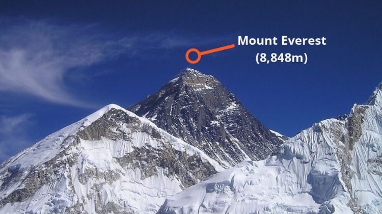
Elevation: 8,848.86 meters
Location: Mahalangur Himal sub-range of the Himalayas, shared between Nepal and Tibet. In Nepal, it falls in the Khumbu region, Sagarmatha National Park.
First Ascent: 29th of May 1953 by Sir Edmund Hillary and Tenzing Norgay Sherpa
Duration: 63 days
Summary
Mt. Everest is named after Sir George Everest. The Everest region has become one of the ultimate adventurous areas in the world.
There are two routes to reach the top of the summit – South Base Camp and North Base Camp. The south base camp is the most commercial one and is commonly used by climbers.
The good news is that climbing Mt. Everest isn’t nearly as difficult technically as other mountains in the world. With the help of Sherpa guides, many people have reached the top.
The weather and altitude sickness are the major factors that can affect one’s summit.
Climbing History
In 1953, history was made. Tenzing Norgay and Edmund Hillary reached the top of Mt. Everest from the south ridge. It was the ninth British expedition led by John Hunt.
Likewise, in 1960, on the 25th of May, a Chinese mountaineering team (Wang Fuzhou, Gonpo, and Qu Yinhua) ascended the peak from the north ridge.
The most fascinating, and I would say mysterious expedition in the history of Everest was the expedition of 1924. On 1924 June 8, George Mallory and Andrew Irvine attempted the summit from the northeast ridge and never returned.
Travel Option
Khumbu region is popular for its numerous adventurous climbing peaks. For instance, Mera Peak, Island Peak. Other than that, you can go on trekking to the Everest Base Camp or go on a helicopter ride to witness breathtaking mountain views.
Kanchenjunga
Elevation: 8,586 meters
Location: Taplejung district in eastern Nepal and borders Sikkim, India
First Ascent: 25th of May 1955 by Joe Brown and George Band
Duration: 65 days
Summary
Mt. Kanchenjunga is the second-highest mountain in Nepal and the third highest in the world. It is one of the most challenging mountains to climb in the Himalayas.
Until the 19th century, Kanchenjunga was known as the highest mountain in the world. After various readings and measurements by the Great Trigonometrical Survey of India in 1849, Mt. Everest was concluded as the highest.
The word Kanchenjunga means the Five Treasures of the Great Snow. It is because the summit comprises five peaks ranging from 8,586 meters to 7,903 meters. Likewise, the treasures represent the five elements gold, silver, gems, grain, and the holy book of gods.
Kanchenjunga is a sacred mountain for the locals. They even call themselves the Children of the Snowy Peaks. To respect the religious sensitivities of the locals, climbers stop a few meters before the summit.
Climbing History
Before the successful ascent of Mt. Kanchenjunga, it took long reconnaissance and numerous attempts. From 1848 to 1899, many explorers explored and climbed different parts of the Kanchenjunga area.
The exploration of the upper Yalung glacier in 1954 to find a possible route to the great ice-shelf that runs across the southwest face of Kanchenjunga led to the successful ascent of Mt. Kanchenjunga in 1955.
On 25 May 1955, Joe Brown and George Band made history to reach the top of the third highest mountain in the world.
Travel Option
There is also an option to go on Kanchenjunga Base Camp Trek that includes an equally adventurous voyage.
Lhotse
Elevation: 8,516 meters
Location: Mahalangur Himal and connects via the South Col. Lhotse is situated on the border of Nepal and the Tibet Autonomous Region of China.
First Ascent: 1956, on 18th May, the Swiss team of Ernst Reiss and Fritz Luchsinger
Duration: 57 days
Summary
Lhotse is the fourth highest mountain in the world and offers exhilarating climbing adventures in the Everest region. Lhotse is also called E1 and consists of three summits.
The highest one is Lhotse Main (8,516 m), and Lhotse Shar (8,383 m) and Lhotse Middle or East (8,414 m) are the other two.
The standard route to the top of Lhotse follows the same path as Mt. Everest. The route ascends to the South Col up to the Yellow Band beyond Camp III. From here, you have to take the left that moves toward Everest and right to the Lhotse face. Before reaching the main peak, the route goes through the narrow Resis couloir.
Climbing History
Lhotse’s climbing history dates back to 1955. The early attempt was made by the International Himalayan Expedition team led by Norman Dyhrenfurth. The team includes two Austrians, two Swiss, and three Americans. The team reached 8,100 meters and had to turn back because of unexpected bad weather.
Later in 1956, on 18th May, the Swiss team of Ernst Reiss and Fritz Luchsinger from the Swiss Mount Everest/Lhotse Expedition reached the summit of Mt. Lhotse.
Likewise, on 12 May 1970, a team from Austria made the first ascent of Lhotse Shar. Whereas, Lhotse middle remained unclimbed for a long time. On May 23, 2001, a Russian expedition climbed the Lhotse middle.
Many expeditions combine Mt. Everest and Mt. Lhotse or just climb solely to the top of Mt. Lhotse.
Makalu
Elevation: 8,481 meters
Location: It is located 19 kilometers southeast of Mt. Everest in the Mahalangur Himalayas on the border between Nepal and Tibet Autonomous Region, China
First Ascent: May 15, 1955, by Lionel Terray and Jean Couzy of a French expedition team
Duration: 75 days
Summary
Mt. Makalu is one of the most difficult eight-thousanders to climb. The steep pitches and knife-edged ridges make climbing Makalu extremely challenging.
The mountain is famous for its incredible shape, like a pyramid. Because of the dark appearance of the mountain, Makalu is also called the Great Black One.
At the base of Mt. Makalu is the stunning Makalu Barun Valley. It is no doubt heaven with high waterfalls cascading into deep gorges, steep rocks rising from lush green forests, and colorful flowers blooming all around the area. Moreover, the Makalu region boasts one of the last pristine ecosystems on Earth.
Climbing History
Mt. Makalu, the fourth highest mountain in Nepal was first ascended on May 15, 1955, by Lionel Terray and Jean Couzy of a French expedition team. The team climbed Mt. Makalu by the north face and northeast ridge. Later, it became the standard route.
In 1971, the very technical west pillar was climbed by Frenchmen B. Mellet and Y. Seigneur. Whereas in 1981, Makalu was climbed via a new route to the northwestern side and north crest.
1990 marked the first female ascent via the west pillar route, and in 2009 Mt. Makalu was climbed for the first time in winter by an Italian team.
Travel Option
Adventurous treks like Makalu Base Camp Trek, Makalu Sherpani Col Pass Trek, Salpa High Pass Trek, etc.
Cho Oyu
Elevation: 8,188 meters
Location: It is located in the westernmost part of the Khumbu sub-section of the Mahalangur Himalaya 20 km west of Mount Everest. The mountain is situated on the Nepal-China border.
First Ascent: 1954 October 19 by Herbert Tichy, Joseph Jöchler, and Sherpa Pasang Dawa Lama
Duration: 45 days
Summary
Mount Cho Oyu is a stunning peak. It’s more of a training mountain before attempting other tough climbs. Because of its simpler approach and safest death route, climbing Cho Oyu is considered simple. Furthermore, it is the most climbed mountain after Mount Everest, and it is also known as a trekking peak.
Cho Oyu means Turquoise Goddess in Tibetan. In the west of Cho Oyu, a few kilometers west of the mountain is Nangpa La Pass (5,716 m). This pass serves as the major trading route between Sherpa and Tibetans. The pass also separates the Khumbu region from Rolwaling Himalayas.
Climbing History
In 1954 October 19, Mt. Cho Oyu was first climbed via the northwest ridge by Herbert Tichy, Joseph Jöchler, and Sherpa Pasang Dawa Lama. It was an Austrian expedition team.
In 1978, the mountain was successfully climbed via the very difficult southeast face by Edi Koblmüller and Alois Furtner.
Whereas, in the winter of 1985, Mt. Cho Oyu had the first winter ascend on the southeast face via a new route without an additional oxygen supply.
Later in 1988, the mountain was climbed via the north face by a Slovenian expedition team.
Travel Option
Besides the Cho Oyu expedition, you can also go for Island Peak climbing or Mera Peak Climbing.
Likewise, as this mountain is located in the Khumbu region, so you can go trekking like EBC Trek, Gokyo Valley Trek, etc.
Dhaulagiri I
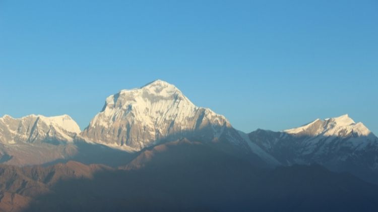
Elevation: 8,187 meters
Location: West-central Nepal, on the western side of the Kali Gandaki river gorge, 65 km northwest of Mt. Annapurna
First Ascent: 13th May 1960 by the Swiss-Austrian expedition team
Duration: 50 days
Summary
Mt. Dhaulagiri (8,167 m) is one of the toughest mountains to climb. It is the seventh highest mountain in the world. Dhaulagiri has five summits that range from 8,167 meters to 7,618 meters.
The entire Dhaulagiri range is located in Nepal and extends 120 km from the Kali Gandaki river in the west to the Bheri in the southwest. Likewise, in the southeast, Myagdi Khola surrounds the mountains.
Dhaulagiri is a Nepali name, which means dazzling white mountain. The east of the mountain has Mt. Annapurna, and the Kali Gandaki river flows between them.
The Kali Gandaki gorge is the world’s deepest gorge. The nearby Annapurna area is famous for trekking, and the Dhaulagiri region is known for off-beat adventure.
Climbing History
Dhaulagiri I was first climbed on 13th May 1960 by the Swiss-Austrian expedition team. Before that, from 1950 to 1959, several attempts were made to reach the top of the mountain.
Later in 1969, an American team attempted to ascent Mt. Dhaulagiri I from the southeast side, and unfortunately, all the team members died in an avalanche.
In 1978, the first ascent was made via southwest ridge led by Amemiya. Sadly, one team member died during the ascent.
The winter of 1985, January 1st, marked the first winter summit of Dhaulagiri I. As of 2007, 358 successful ascents have been made, whereas 58 fatalities are seen.
Travel Option
To enjoy the breath-taking beauty of Mt. Dhaulagiri, you can join Dhaulagiri Base Camp Trek or Dhaulagiri Circuit Trek.
Manaslu
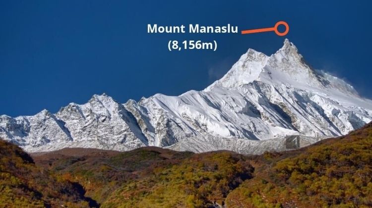
Elevation: 8,156 meters
Location: It is part of the Mansiri Himal, situated in the west-central part of Nepal in the Gorkha district, 64 k east of Mt. Annapurna
First Ascent: 1956 May 9 by Toshio Imanishi (Japan) and Gyaltsen Norbu (Sherpa)
Duration: 50 days
Summary
Mt. Manaslu (8,156 m) is the eighth highest mountain in the world. The word Manaslu means Mountain of the Spirit.
There is a famous saying by Sir Edmund Hillary that says, “just as the British consider Everest their mountain, Manaslu has always been a Japanese mountain.”
Climbing this mountain is technically difficult. The mountain is part of the Manaslu Conservation Area Project. The trail also crosses the Larkya La Pass (5,106 m).
Climbing History
On 1956 May 9, Toshio Imanishi (Japan) and Gyaltsen Norbu (Sherpa) made the first successful ascent.
Later in 1971, a Korean expedition team attempted to reach the top of Mt. Manaslu via the northeast face, and in 1972 the southwest face was climbed by an Austrian expedition team.
1981 saw many expeditions. In the same year, a French expedition team explored a new route that involved a variation of the west face route. Similarly, on January 12, 1984, the first successful winter attempt was made via the normal route.
Later in 1986, Jerzy Kukuczka, Artur Hajzer, and Carlos Carsolio became the first people to climb the east summit of Manaslu.
Travel Option
Some famous trekking packages are Manaslu Circuit Trek and Tsum Valley Trek.
Annapurna I
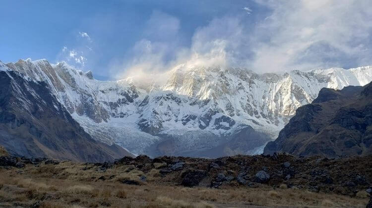
Elevation: 8,091 meters
Location: North-central part of Nepal in the Annapurna region
First Ascent: June 3, 1950, by a French Expedition team
Duration: 45 days
Summary
Mt. Annapurna is surrounded by the Kali Gandaki gorge in the west, Marshyangdi River on the north, and Pokhara valley in the south. It falls under the protected area called Annapurna Conservation Area.
The Annapurna has six 7,000 meters above peaks ranging from 8,091 meters to 7,455 meters. Even though this mountain was the first eight-thousander to be climbed in the history of human mountaineering, the peak is considered dangerous.
The extremely steep south face of Annapurna I involves a wall of rock (3,000 m). The fatality rate is 32%, the highest among all the eight-thousanders.
Climbing History
French Expedition team climbed Mt. Annapurna on June 3, 1950. You can see this marvelous achievement in the documentary called Victoire Sur l’Annapurna.
In 1970, the south face of Annapurna was climbed by Don Whillans and Dougal Haston without supplemental oxygen. While descending, Ian Clough got killed by falling serac.
Travel Option
Annapurna Base Camp Trek and Annapurna Circuit Trek are the most famous treks in the region. For a short trek, go on the Ghorepani Poon Hill trek or Mardi Himal Trek. Likewise, Nar Phu Valley Trek is an off-beat trek.
Gyachung Kang
Elevation: 7,952 meters
Location: Mahalangur Himal section of the Himalayas, on the border between Nepal and China
First Ascent: June 3, 1950, by a French Expedition team
Duration: 51 days
Summary
Gyachung Kang is the fifteenth highest peak in the world. Moreover, it is also the highest peak, which is not eight thousand meters tall. The mountain is situated between Mt. Everest and Mt. Cho Oyu.
Gyachung Kang is a difficult peak to climb. On top of that, the lack of significant prominence also contributes to its relative obscurity.
Climbing History
Gyachung Kang was first climbed by Y. Kato, K. Sakaizawa, and Pasang Phutar on April 10, 1964. On the next day, K. Machida and K. Yasuhisa climbed the peak.
Later in 1999, a Slovene expedition team climbed the peak via the north face and was repeated by Yasushi Yamanoi in 2002.
Travel Option
Being a part of the Khumbu region, Gyachung Kang lets you enjoy the breathtaking scenery and offers famous trekking and climbing packages in the region.
Annapurna II

Elevation: 7,937 meters
Location: It is a part of the Annapurna mountain range in western Nepal
First Ascent: 1960, by British/Indian/Nepalese team led by J. O. M. Roberts via the West Ridge, approached from the north
Duration: 40 days
Summary
Annapurna II is an independent peak even though closely associated with Annapurna I. It is the 16th highest mountain in the world.
The usual route to the top of the mountain goes through the west ridge. The route involves considerable descent and ascent on the return. Not many climbers have attempted to scale Annapurna II because of it 3 kilometers ridge at an elevation over 7,000 meters.
Like any other mountain, the climbers have to possess technical skills, previous climbing experience, and strong physical and mental stability.
Climbing History
Annapurna II was first climbed in 1960 by Richard Grant, Chris Bonington, and Sherpa Ang Nyima, members of the British/Indian/Nepalese expedition team led by J. O. M. Roberts. They have climbed the mountain via the west ridge, approaching from the north.
Later in 1973, a Japanese citizen, Katsuyuki Kondo, discovered a short route that climbs directly up the north face between IV and V before continuing along the west ridge.
Likewise in 1983, Tim Macartney-Snape reached the summit via the first ascent of the south spur. And after many years, in 2007 Philipp Kunz, Lhakpa Wangel, Temba Nuru, and Lhakpa Thinduk made the first winter ascent.
Travel Option
As the Annapurna range consists of six prominent peaks, you can climb 5 other peaks too. Likewise, there are also options to climb other peaks out of the Annapurna range.
Conclusion
Apart from these eight mountains, there are more than 1,300 six-thousand peaks in the Himalayas of Nepal. And among them, 414 peaks are open to climb.
Climbing a peak is not the only way to experience the thrill the Himalayas have to offer. There are treks around those mountains, which offers an equally rewarding venture.
Check out the Best Places to Visit in Nepal for more information. Likewise, our blog Best Time to Visit Nepal will give you comprehensive information about the weather and climate around the Himalayas.


